It was a beautiful morning, cool to cold, sunny and not very windy, but we still expected that the Baker Island trip would be canceled for some reason or other. Rich and I took our Hannaford-Bananaford “apple” turnovers down to the waterfront, along the way picking up coffee and Earl Grey tea from the Trailhead Cafe. We sat on the stone retaining wall where the “Indian” sat yesterday and bit into our slightly dry turnovers, only to find out that they were raspberry and not apple. They were still surprisingly tasty for grocery store bakery fare. Or maybe we were just hungry.
A few minutes after 8:00am, we approached the desk at the Bar Harbor Whale Watch Company for the third time this week. The girl at the desk was grinning when she told me that yes, the Baker Island tour is going out today!
The tour boat, Miss Samantha, left promptly at 8:45am. The ranger, Kirk Lurvey (the name will be important later) looked like Dudley Do-Right, Rich remarked, and it really was true. But he was an excellent guide, and as we learned as the day went on, he really was the best ranger for this particular program. so maybe it was for the best that we didn’t get to take the trip on Friday, when he wouldn’t have been giving the tour (since he is also a teacher at the local high school).
On the way to the island, Rich and I watched the GPS from time to time as we passed the typical landmarks (Porcupines, Egg Rock, Thrumcap, East Bunker Ledge [site of PE1784: BUNKER LEDGE MONUMENT]) waiting for the approach of Islesford and the landmark station, TOW, that is supposed to be on the southeastern tip quite close to Baker Island (Life Saving Station #4, closed in 1946, now a private residence). Along the way we also saw the typical gulls and cormorants, in addition to harbor porpoises.
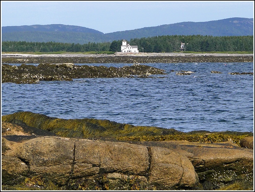
By the time we were nearing the Cranberries, the wind and wave action had picked up and the boat was rocking side to side. I was able to get a few photos of the tower on the old station from the boat regardless of the motion; we weren’t sure how good a view we might have from Baker Island, so we wanted to get a half decent shot while we could.
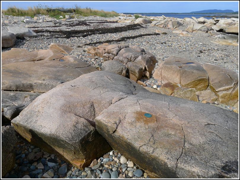
In order to land on Baker Island, we had to board a small skiff in three groups. Rich and I were in the first group and had a fun, bouncy ride onto the rocky beach. And what did we see as soon as we climbed down the ramp? Yes, a survey disk set into a ledge right at eye level, its bright green-blue color standing out so brightly against the sand-colored background of the rock! We knew nothing about this station and cannot find it on any maps. And it’s so weather-beaten that the stamping is almost completely obliterated. Nothing can be distinguished other than some of the letters around the outside of the disk spelling U S DEPARTMENT OF THE INTERIOR. It appears to be an NPS boundary marker similar to others we’ve found in the park.
After documenting the mark as well as possible, Rich and I wandered along the path cut into the grass toward a small cemetery just to the west of the landing spot. Some beautiful red mums were growing next to one gravestone.
We strolled around until everyone had come on shore, at which point the ranger continued telling us the story of Baker Island. This was the story of Hannah Lurvey Gilley, a native of Southwest Harbor born in 1782, her husband William, and their twelve children. They settled on the island to gain the advantage of being closer to William’s favorite fishing areas. Their lifestyle was relatively typical of people who settled/squatted on these islands. Survival depended on the gulf’s abundant fish and lobster, their flocks of sheep, and supplies they made themselves or brought occasionally from the mainland. They survived extremely harsh winters, heavy labor, and often pure isolation. But they also experienced great beauty and peace.
Then came the lighthouse in 1829—a game-changer. After political disagreements William Gilley refused to serve as the lightkeeper and eventually left to settle on a nearby island, while Hannah stayed on Baker Island with her children and, by then, grandchildren. The island was pretty well populated until the 1930s, when the advent of motorboats offering quick transport from the mainland to fishing spots led to an exodus of most people from remote island living.
We saw the preserved homestead, two-seater outhouse (which a whole lot of people used before getting back onto the boat!), a few currently occupied residences, the tiny whale oil museum in the old oil house for the lighthouse, and of course the lighthouse itself.
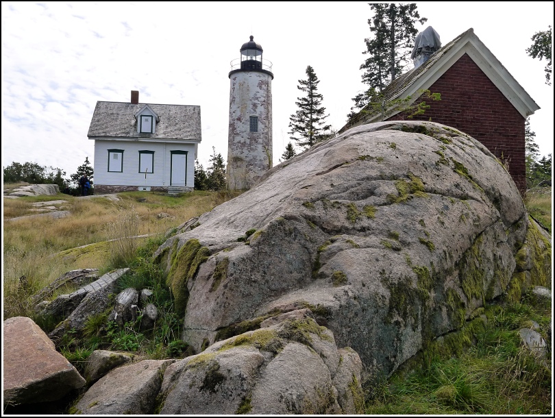
The ranger mentioned that the lighthouse had recently been given to the park by the Coast Guard but he wasn’t yet sure what the plans are for it. Possibly it will become a museum of some kind. He mentioned that some artifacts from the island, like Hannah’s spinning wheel, are in other museums nearby. And of course the big reveal, which several of us had figured out in advance due to his last name, was that the ranger was in fact a relative of Hannah-she was, I believe, his great-great aunt.
We had about half an hour, maybe a little more, to hike a very pleasant wooded path lined with moss, blueberry and mountain cranberry to the bright, smooth rock ledges on the south side of the island, called the “dance floor,” where we ate our snack (appropriately, Lamb Chopper sheep’s milk cheese! and crackers) and rested for a while (and, I admit, checked to see if there might be another topo station-there wasn’t that we could see) before hiking back north, reboarding the skiff, and returning to Bar Harbor.
On the return trip we came closer to shore despite the very choppy water, and we got a little tour of the typical shoreline sites that never get old (Otter Cliff featuring rock climbers in action, Great Head, which is of particular importance to us today, Thunder Hole, “our spot,” even Anemone Cave. I can’t believe the ranger even mentioned the cave, but I’m glad he did. He even asked Rich if he knew when the cave last appeared on the official park maps. And on the way back Rich had a good conversation with him about abandoned trails. We asked about Sheep Porcupine and he said there were no trails to the summit that he’s aware of, but that he knows someone goes there to band eagles—which we had also heard last year from our kayaking guide Brescian. We told him about finding the Pothole Trail, which he somehow wasn’t aware of. In return, he described to us a set of hanging steps leading down from near the Bowl toward a trail, marked by cairns and still discernible, that heads up Enoch Mountain. You can guess what we’re doing tomorrow!
Our anniversary dinner tonight was at Havana, since the Town Hill Bistro is no more. We began with the customary mojitos and a complimentary treat of tuna with pickled onion on a corn tortilla chip, blueberry and feta cornbread and Agnes’s sourdough with blueberry jalapeno butter, spicy olive oil, and white bean spread. I could make a meal out of their breads and toppings alone!
But it’s no surprise that we ordered a lot more than bread. We started with one of our favorite appetizers: spring rolls filled with roasted mushrooms and soba noodles and topped with a soy sauce and truffle aioli. We get at least one order of these each year at Havana.
We were both in a meat-eating mood after all the adventures of the day. Rich chose the filet mignon, which they were serving with a coffee rub and topped with oyster mushroom sauce. Along with the filet came red flannel hash and Brussels sprouts with a jerk seasoning. I had the cochinita pibil, which is basically pulled pork in a banana leaf with black beans and picked onions. Accompanying sauces were scotch bonnet salsa(hot!) and a roasted red pepper sauce(not!).
We were stuffed to the “Gilleys” but I find it impossible to resist dessert at Havana. We shared a double espresso and Catalan Spiced Custard with an apple brandy compote and pistachio brittle. We both noted that this custard would be absolutely awesome on plum pudding - possibly even to rival mom’s famous brandy sauce!